Location of Brook Hall Ditches / Brook Hale Ditches (General)

by Edith Hughes, (5269 days ago)

I am trying to find the location of Brook Hall Ditches/Brook Hale Ditches.
The information re. my ancestors is as follows:-

Marriage; Elizabeth Wintle to William Thomas
at the Parish Chapel, Park End, on 27th August 1861.
Bride's residence: Brook Hall Ditches.

Burial: James Harris, of Brook Hale Ditches,
at Park End Parish Chapel on 24th November 1875.

Any information would be appreciated.

Edith Hughes (nee. Harris)

Location of Brook Hall Ditches / Brook Hale Ditches

by Jefff, West London, Middlesex, (5269 days ago) @ Edith Hughes

Using Advanced search I find the full Marriage Record:

Record ID 14694
Entry Number 483
Year 1861
Month Aug
Day 27
Grooms Surname THOMAS
Grooms Forenames William
Grooms Age 22
Groom Condition Bachelor
Grooms Occupation Stone Cutter
Grooms Residence Coalway Lane End
Grooms Fathers Surname Thomas
Grooms Fathers Forenames Benjamin
Grooms Fathers Occupation Collier
Brides Surname WINTLE
Brides Forenames Elizabeth
Brides Age 18
Brides Condition Spinster
Brides Occupation [not stated]
Brides Residence Brook Hale Ditches
Brides Fathers Surname Wintle
Brides Fathers Forenames George
Brides Fathers Occupation Collier
Licence or Banns Banns
Date of Banns
Signature or Mark both sign
Witness 1 George Wintle
Witness 2 Henry Gunter
Other Witnesses
Officiating Minister [illegible] Ebsworth
Event Marriage
Memoranda Incumbent
Notes
Register Reference P145 IN 1/20
Page Number 242
Parish Chapel Parkend

Presumably this is the same Elizabeth?

Record_ID: 49907
Entry_Number: 370
Year: 1843
Month: Feb
Day: 5
Parents_Surname: WINTLE
Child_Forenames: Elizabeth
Fathers_Forenames: Georg
Mothers_Forenames: Elizabeth
Mothers_Surname:
Residence: Whitecroft
Occupation: Collier
Officiating_Minister: Henry Poole
Event: Baptism
Memoranda:
Notes:
Register_Reference: P245 IN 1/10
Page_Number: 47
Parish_Chapel: Parkend
Soundex: W534

Or perhaps ?

Record_ID: 49918
Entry_Number: 381
Year: 1843
Month: Apl
Day: 9
Parents_Surname: WINTLE
Child_Forenames: Elizabeth
Fathers_Forenames: George
Mothers_Forenames: Mary Ann
Mothers_Surname:
Residence: Whitecroft
Occupation: Collier
Officiating_Minister: Henry Poole
Event: Baptism
Memoranda:
Notes:
Register_Reference: P245 IN 1/10
Page_Number: 48
Parish_Chapel: Parkend
Soundex: W534

From this presumably Brook Hall/Hale Ditches is/are in the Coalway/Whitecroft/Parkend area ?.

Location of Brook Hall Ditches / Brook Hale Ditches

by Jefff, West London, Middlesex, (5269 days ago) @ Jefff

I'm NOT particularly au fait with the Parkend/Whitecroft area so I'm more than happy to be corrected. However after much Googling, searching the FoD website including Advanced search of this place name in the PRs, and studying old maps sites I wonder if it's related to what is now the hamlet of Brockhollands ?.

From this highly recommended website you can enlarge & study several old maps.
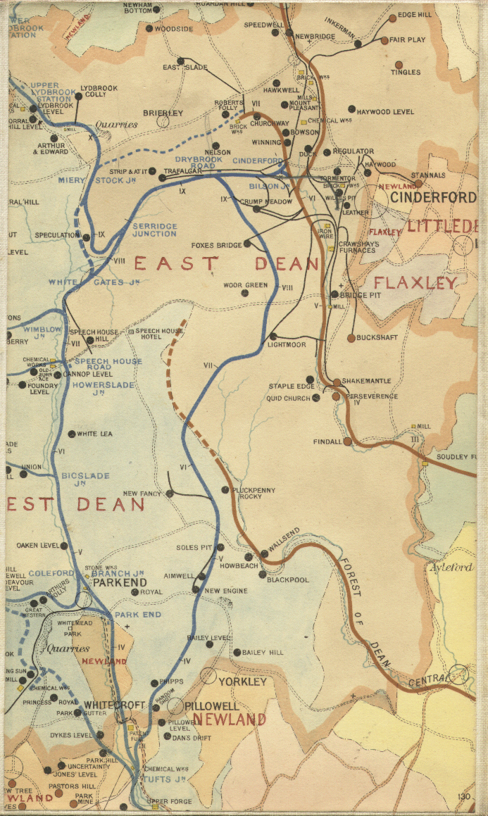
Drop down the menu above the map and select the B&W C19th map, click on "bigger map" to enlarge it around Parkend/Bream. "Drag" cursor to move around the map, or further enlarge it.

http://www.visionofbritain.org.uk/maps/index.jsp?layer=europe&xMin=3163681.93101&am...

To me this map appears to clearly read BrookHollands Farm (ie NOT Brock) just north of the Meer Brook, just south of Whitecroft. There are other brooks north of here.

This development was built-up and called "Brockhollands" largely after the above Baptisms etc were recorded; where did they get the name from ?.

Also see http://www.british-history.ac.uk/report.aspx?compid=23266&strquery=brockholland

and track down past the map of Bream (which can be enlarged) until you see "Brockhollands" highlighted in green, which states.

"South-west of Whitecroft there were half a dozen cottages on Saunders green in 1834. (fn. 52) Later the small hamlet of Brockhollands, on a hillside above Cannop brook, was formed north-west of an ancient farmstead within Newland parish. (fn. 53) A row of brick cottages had been built near the road from the Tufts to Bream by the early 1870s when, following the diversion of a new road to Whitecroft, a land society sponsored by a Conservative building society laid out roads for a housing estate lower down the valley side.

I happily look forward to yet another of my "good" theories being scotched !

ps regarding variations of spellings,
the Old English word "broc" means "brook" or "stream", whereas the Old English word "brocc" means "badger".
Simple, eh ?.

Brockweir Ditches+ previous thread

by m p griffiths, (5269 days ago) @ Edith Hughes

previous thread

http://www.forum.forest-of-dean.net/index.php?id=13979


If you look at the FOD records - George & Ann WINTLE - Son David - address: Brookhall Ditches (Parkend - 6 September 1846- parents George : Engine Driver, and Mary Ann


1851 Census, West Dean - District 8

BROCKWEAR
Ditches

WINTLE

George - 26 - Engine Drive, born West Dean
Mary - 26
Eliza - 8
David - 4
George 1


Description of Enumeration District 8

All that part of the Township of West Dean comprising the Fetterhill? Parkend, Parkhill inclosure, Birches Pit, Brockwear Ditches, Moseley Green, Russels Inclosure and the Speech House.


few houses before WINTLE, Speech House ........Burnt Leg, Baraks, Brockweir Ditches, then Baraks again


1861 Census, West Dean, District 10

Oak Hill Level

then

Brockweir Ditches

WINTLE

George - 39 - Engine Driver
Mary Ann - 37
David - 14, labourer
George - 11 - Fire Boy
William - 8
Mary Ann - 6
Sarah Ann - 3
Rhoda Ann - 1

then Parkend

Location of Brook Hall Ditches / Brook Hale Ditches

by terry2424, LYDNEY FOREST OF DEAN, (5269 days ago) @ Edith Hughes

Hi
I beleve that the area called Brocca ditches (how ever its spelt or pronounced)is on the left hand side of the road between Parkend and the turning for the Speech House I think its called New Fancy road
Terry

Location of Brook Hall Ditches / Brook Hale Ditches

by PEG, (5269 days ago) @ terry2424

I agree with Terry in his location of Brookhall Ditches (frequently referred to as Brocca Ditches / Broccal Ditches). I used to live in the "old doctors house" (now called "Newhaven") - the 2nd last house on the right when leaving Parkend when travelling up the Fancy Rd (New Fancy Rd) towards the Barracks / left turn to Speech House junction. I recall seeing some old property documents relating to Newhaven & there was mention of Brookhall Ditches in the description of the location of the house. I also seem to recall some references to coal mines in the Brookhall Ditches area as well. As a young lad in the late 1960s I remember dropping stones down what my father (Eric Gwynne) told me was a mine air shaft, just across the road from Newhaven & hearing them splash into the flooded shaft many seconds later. The shaft was eventually filled with numerous truckloads of old tyres & capped with concrete in the late 1960s / early 1970s.

Regards,
PEG

Location of Brook Hall Ditches / Brook Hale Ditches

by Jefff, West London, Middlesex, (5268 days ago) @ PEG

Looks like "local knowledge" has triumphed over the "appliance of science" (well guesswork) again, which is great !.

Looking again at the "Vision Of Britain" site I mentioned earlier and at the same Black & White C19th Map, but now look at Parkend(Furnace) and northeast across Church Hill. (This link finds the complete map, track cursor to middle of bottom edge and zoom in to find Parkend etc in superb detail).
http://visionofbritain.org.uk/iipmooviewer/iipmooviewer.html?fileName=first_edition%2Fs...

There was no Fancy Colliery at that time the map which is presumably why there is also no Fancy Road. The map is a First Series Ordnance Survey dated 1831. The map clearly shows a brook running across the land north of Church Hill at the Forest's edge, just where Fancy Road now runs towards the Barracks etc. I guess this brook is the one in question.

Finally, looking a little more east this map shows Brandet's Green. The later maps call this Brandrick's Green. This goes to show that things we now assume to be "reference material" such as Government OS Maps could themselves be affected by spelling/interpretation inaccuracies just as we see on Census Returns etc etc.


PS this portion of the 1894 Railways & Mines Map suggests the airshaft mentioned by PEG is from the "Royal" mine.
http://www.lightmoor.co.uk/forestcoal/East%20Dean.JPG

Also see article http://www.lightmoor.co.uk/forestcoal/CoalRoyal.html

Re the Fancy Pit, it appears that although the gale was being worked from abt 1840 (accessed via the Parkend gale), the shafts were being sunk at Fancy at abt 1852. Hence the need for the road from Parkend.
http://www.lightmoor.co.uk/forestcoal/CoalNewFancy.html

RSS Feed of thread